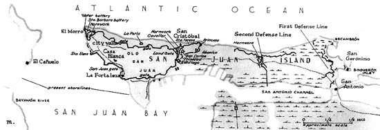
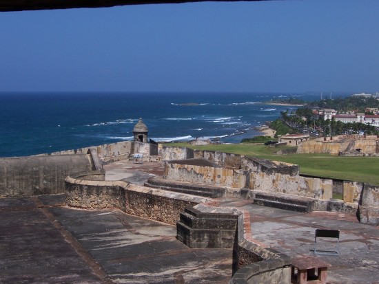
Fort San Felipe Del Morro:
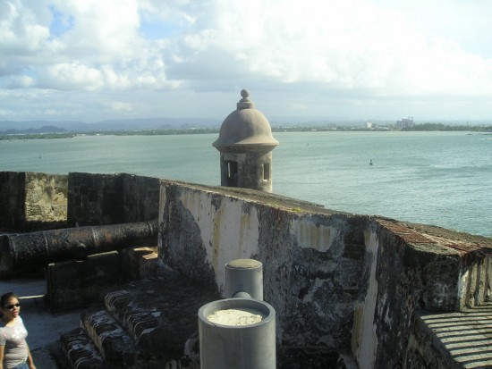
Lookout Tower
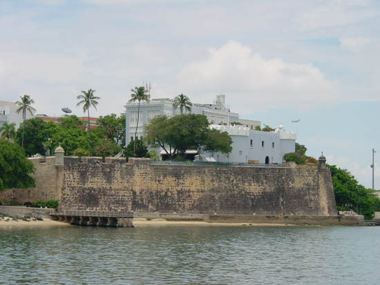
Fort San Felipe del Morro or El Castillo San Felipe del Morro in Spanish is a sixteenth-century citadel which lies on the northwestern-most point of the islet of San Juan, Puerto Rico. Named in honor of King Philip II of Spain, the fort, also referred to as “El Morro” or “promontory”, was designed to guard the entrance to San Juan bay, and defend the city of San Juan from seaborne enemies. In 1983, the fort was declared a World Heritage Site by the United Nations and is part of San Juan National Historic Site. Over two million visitors a year explore the windswept ramparts and passageways making the fort one of Puerto Rico’s main visitor attractions. Facing “El Morro”, on the opposite side of the bay, a smaller fort known as “El Cañuelo” complemented the fort’s defense of the entrance to the bay. The construction of the Fort San Felipe del Morro begun 1539 when King Charles V of Spain authorized its construction, including the surrounding walls. The purpose was to defend the port of San Juan. Construction started the same year with a tiny proto-fortress that was “completed” in 1589. This small section comprises perhaps 10% of the structure people see today.
In 1587, engineers Juan de Tejada and Juan Bautista Antonelli designed the actual appearance of the castle as seen today, following well established Spanish military fortification design principles. Similar Spanish fortifications of the 1600s-1700s can be seen in Cuba, St. Augustine, Florida, Santo Domingo, Dominican Republic, Veracruz and Acapulco, Mexico, Portobello and Panama City, Panamá,and many other Latin American locations which were governed as part of the Spanish Empire during the Age of Exploration. Many complex additional new structures were added to El Morro over the next 400 years. The outer walls are six meters thick. In 1680, Governor Enrique EnrÃquez de Sotomayor begun the construction of the walls surrounding the city of San Juan, which took 48 years. By the late 18th century, El Morro’s walls had grown to be 18 feet (5.5 m) thick. Today El Morro has six levels that rise from sea level to 145 feet (44 m) high. All along the walls are seen the dome-covered sentry boxes known as garitas, which have become a cultural symbol of Puerto Rico itself. The El Morro or Port San Juan Light was built atop the fort in 1843, but in 1908, it was replaced by the US military with the current lighthouse.
Fort San Cristobal:
San Cristobal Fort
The Castillo de San Cristobal is a Spanish fort in San Juan, Puerto Rico. It was built by the Spaniards to protect against land based attacks on the city of San Juan. It is part of San Juan National Historic Site. Castillo de San Cristobal is the largest fortification built by the Spanish in the New World. When it was finished in 1783 it covered about 27 acres of land, basically wrapping the city of San Juan. Entry to the city was sealed by San Cristobal’s double gates. After close to one hundred years of relative peace in the area, part of the fortification (about a third) was demolished in 1897 to help ease the flow of traffic in and out of the walled city.
Most of San Juan’s fortified walls have guerites (sentry boxes) at various points. One of the guerites at Fort San Cristobal is called “The Devil’s Guerite” (“La Garita del Diablo”). This particular guerite is one of the oldest parts of the fort being built in 1634. Legend says that soldiers disappeared randomly from the guerite. However, it is mostly believed – and told so in various local stories – that the only soldier that apparently disappeared did so to escape with his girlfriend. However, the legend still surrounds the guerite and most people ask for it when visiting the fort.
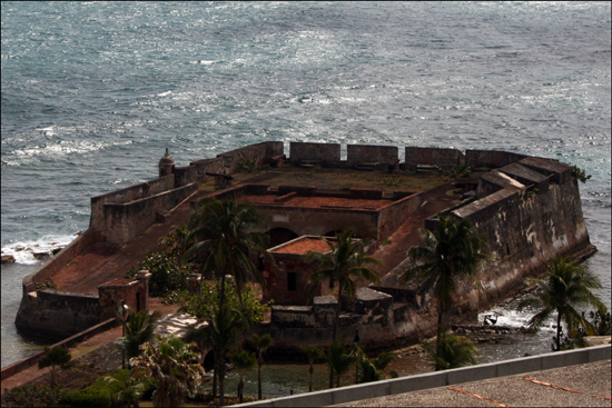
El Cañuelo:
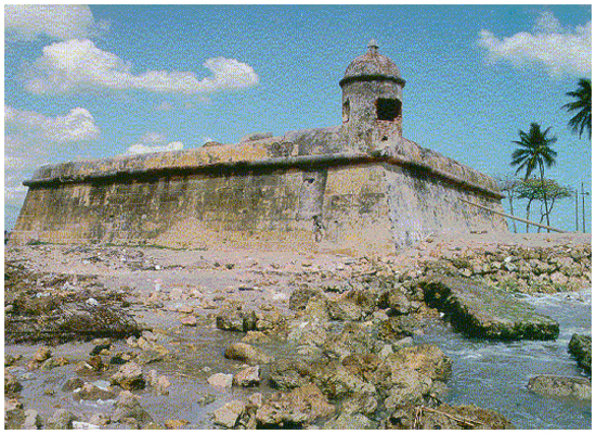
El Cañuelo
Fortin San Juan de la Cruz (Fort Saint John of the Cross), better known as el Cañuelo, is located on Isla de Cabras, Puerto Rico. It is part of San Juan National Historic Site. This fort was originally built in wood in 1610. Due to its location at the entrance of the San Juan bay, and in front of the Fort San Felipe del Morro, across the bay, it provided a strategic point to create a crossfire for any invading ships entering the bay, filling a gap in the artillery coverage. It is said that, at one time, there was a huge chain crossing from El Morro to El Cañuelo that was stretched during attacks to provide a physical barricade across the bay entrance. The fort also guarded the mouth of the Bayamon River on the other side.
The fort played an important role during a Dutch attack to the island. At that time it was burnt to ashes. However, the Spaniards rebuilt it in the 1670s. The square fort is about 80 feet (24 m) per side, with one guerite (garita in Spanish). Originally built on a rocky islet, nearby Isla de Cabras (Goat Island) was artificially expanded to incorporate it. Although difficult for tourists to find, the site features fabulous views of Boca Vieja Cove to the west and San Juan Bay to the east. The fort interior is closed to the public, but one can walk around its walls. Isla de Cabras is connected to the main island by a causeway.
La Fortaleza:
La Fortaleza
La Fortaleza, (The Fortress) is the current official residence of the Governor of Puerto Rico. It was built between 1533 and 1540 to defend the harbor of San Juan. The structure is also known as Palacio de Santa Catalina (Santa Catalina Palace). It is the oldest executive mansion in the New World. It was listed by UNESCO in 1983 as a World Heritage Site. During the 1640 reconstruction, the chapel of Santa Catalina, which originally existed outside of the walls, was demolished and was integrated to the walls of the structure. This would give rise to the name of Santa Catalina’s Palace. La Fortaleza was the first defensive fortification built for the city of San Juan, and the first of a series of military structures built to protect the city which included the Fort San Felipe del Morro and the Fort San Cristobal. The construction was authorized by Charles V as a defense against attacks from the European powers of the day and Carib Indians.
Initially, the structure consisted of four walls enclosing an interior patio with a circular tower known as the Homage Tower. From the top of the tower, the governor, following military tradition, would take oaths of fidelity at critical moments to the Queen and the King of Spain. Later, a second tower named the Austral Tower was constructed. At present, the complex consists of a few attached buildings with formal living quarters in the second floor, and private quarters in the third. It overlooks the high city walls that front the bay, and within the north perimeter of the house are sheltered gardens and a swimming pool.
Fortin De San Geronimo:
Fortin de San Geronimo
Fortin de San Geronimo del Boqueron (Fort Saint Jerome of the Large Entrance) is a small fort located in the entrance to what is known today as Condado Lagoon in San Juan, Puerto Rico. It was built during the 17th century to replace a smaller battery (called El Boqueron) that stood at the easternmost end of the San Juan islet. The original Boqueron battery defended San Juan from attacks by Sir Francis Drake in 1595 and George Clifford, the third Earl of Cumberland, in 1598 who destroyed it after his attack. The San Geronimo became part of San Juan’s First Line of Defense, along with the San Antonio Fort/Bridge and Escambron Fort, being the Fourth and final Line of Defense the majestic San Cristobal Castle, guardian to the city entrance
Fortin Conde De Mirasol:
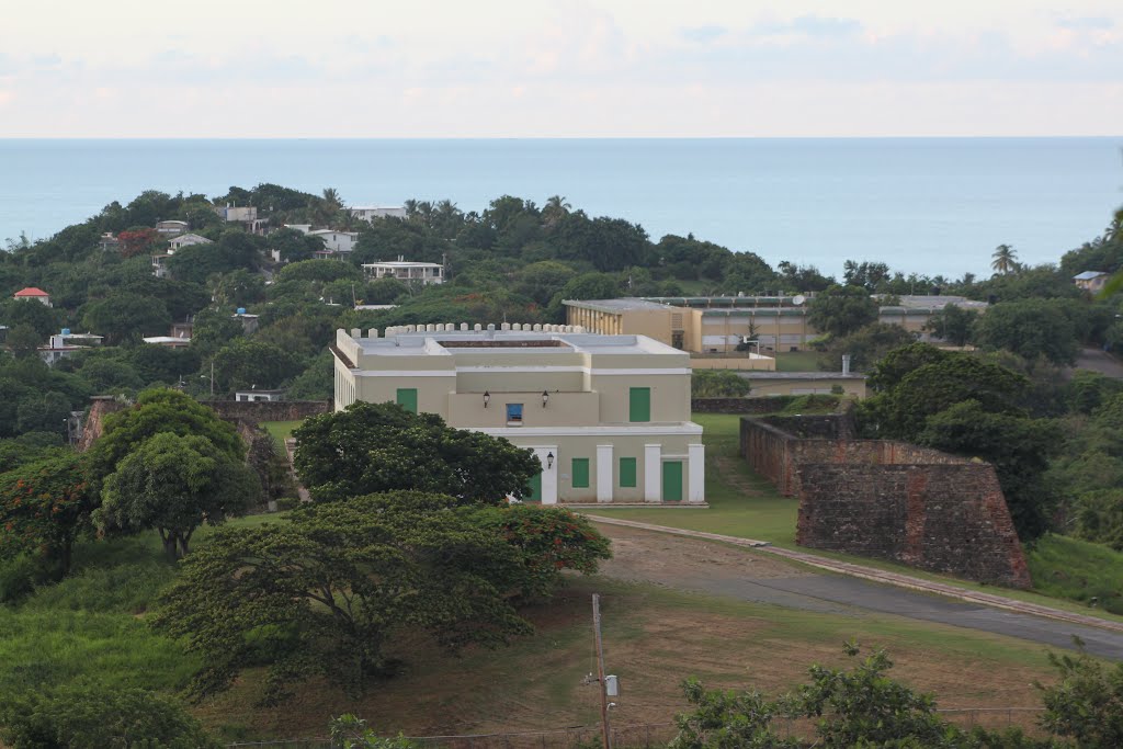
Fortin Conde De Mirasol
Fuerte de Vieques, also known as El Fortin Conde de Mirasol, is a fort built in 1845 located in the town of Isabel Segunda in Vieques, an island municipality of Puerto Rico. In 1991, the fort was restored by the Institute of Puerto Rican Culture. The structure houses the Vieques Museum of Art and History and the Vieques Historic Archives, an extensive collection of documents related to the history of Vieques. Perched on a hilltop, overlooking the small Vieques town of Isabel Segunda, is a tiny castle with low stone walls and a small white-plastered fort. The walls are lined with cannons, and wild horses graze on the grassy slopes below. The Fuerte de Conde de Mirasol, locally known as El Fortin, was the last fort built by the Spanish in the New world. Construction began in 1845, but never completed. The main structure was used by local governments as a jail into the 1940’s. The Fortin was later abandoned and fell into disrepair. An extensive renovation and restoration project completed in 1991.
The Fortin is now the center of Vieques culture and history. The museum has permanent exhibits of native Taino and Spanish tools and artifacts, and hosts many exhibitions by artists from Puerto Rico and around the world. Visitors can take a self-guided tour of the museum and grounds. The museum’s staff are extremely knowledgeable and informative. The Fortin itself offers sweeping panoramic views of Isabel Segunda, the Puerto Rico Mainland, Culebra island, and St. Thomas. The Fortin hosts numerous events throughout the year; presentations, documentary films, exhibits and much more.


