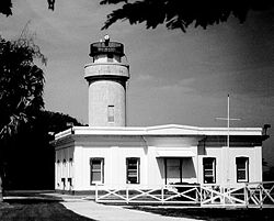
 Inactive since 1918, when the lighthouse was nearly destroyed by a tsunami. The lighthouse was an octagonal cylindrical stone tower with lantern and gallery, rising from a 1-story stone keeper’s house, similar to the Cabo San Juan lighthouse. Foundations and portions of the walls are standing. This lighthouse was very similar to the surviving Maunabo lighthouse Located at the northwestern tip of the island, about 1.25 miles from the present lighthouse. Lantern has been removed. The 1-story keeper’s house is used as vacation housing for Coast Guard personnel. The lighthouse is adjacent to a popular golf course built on the former Ramey Air Force Base. Borinquen is the original Indian name of Puerto Rico. Located north of Aguadilla near the northwestern most point of the island.
The first Aguadilla lighthouse, locally known as Las Ruinas (the ruins), entered service on September 15, 1889. It was designed by Enrique Gadea and built by Pedro Tolosa at Point Borinquen, the northwest tip of the island. The engineers considered building the lighthouse on the higher ground where decades later its substitute was built, but concluded that the many cracks present there would make it more vulnerable to earthquakes. Lack of satisfaction with its visibility from the northeast led in 1911 to a request for funds to destroy it and build a new lighthouse.
In 1918, before work on the new lighthouse had started, a strong earthquake severely damaged the tower and weakened the rest of the structure to the point that shortly afterwards it was closed and abandoned, to the ravages of the weather and vandalism. Today the only remains of this elegant lighthouse, which measured 91 feet long and 41 feet wide, are the front facade and one lateral wall. We can nevertheless have the illusion of visiting it through its twin brother, the Maunabo lighthouse; these two structures were distinguished only by their color and the details of the tower’s cornice, which in the Aguadilla lighthouse exhibited elaborate Moorish details. The building was painted red and white, part of the red paint, now very bleached by the sun, remains on the stucco of the front wall. The octagonal tower was 45 feet high and was located at the center of the building. The fourth-order lens, destroyed by the earthquake, projected its light twelve miles away, illuminating the northwest tip of Puerto Rico and the entrance to the Mona Passage.The second Aguadilla lighthouse entered service in 1922, substituting the original lighthouse destroyed by an earthquake in 1918. It was constructed little more than a mile away from the first lighthouse and over 200 feet above sea level, on the area then known as Punta Gorda. Here the light was more visible to the ships that sailed from Europe to the Panama Canal. This tower is 60 feet tall and does not connect to the keepers’ residence, which measures 56 feet long by 40 feet wide.
The third-order lens was constructed by the Macbeth Company in New York and projected its light 18 miles away. As in the other lighthouses, the weights that rotated the lens descended through the column of the spiral iron stairway. In 1947 the lantern was removed and the lens was substituted by a pair of search lights more appropriate for air travel, since by then the lighthouse was located in the Ramey Air Force base. Years later these lights were substituted by the smaller pair used today. The tower was finally automated in 1976. Access to the lighthouse grounds is limited to Coast Guard employees who rent the residence. The living rooms of both apartments conserve the white, gray, and black tiles installed in 1922. The lighthouse can be observed from the entrance gate and from the adjacent golf course.


